Lyft Uses Mapping Intelligence to Reduce Friction in Gated Community Pickups
Our take
Lyft’s recent announcement regarding improved pickup experiences within gated communities is far more than a minor operational tweak; it’s a compelling illustration of how real-world constraints are actively shaping the evolution of geospatial systems and, crucially, the practical application of AI. The 25-30% failure rate they’ve observed highlights a surprisingly persistent challenge in ride-sharing, and their solution, built on mapping intelligence and boundary detection, speaks to a growing need for nuanced, context-aware AI. It’s a fascinating parallel to the challenges tackled in time series forecasting, as explored in [Prophet vs NeuralProphet vs TimeGPT vs Chronos: A Practical Comparison], where similar complexities in data patterns require sophisticated modeling to achieve accurate predictions. Furthermore, the focus on improved routing and reduced coordination echoes the broader trend of integrating AI into operational workflows, a trend underscored by the tools discussed in [Top 10 AI Engineering Tools Everyone is Using in 2026]. This isn’t about flashy new algorithms; it's about strategically applying AI to solve tangible, everyday problems.
The brilliance of Lyft's approach lies in its pragmatic focus. Rather than attempting a sweeping overhaul, they’ve identified a specific pain point – gated communities – and designed a targeted solution. This underscores the shift away from the hype surrounding generalized AI towards a more practical, problem-driven application. The system’s reliance on mapping signals and boundary detection demonstrates the increasing importance of geospatial data in AI development. It’s a recognition that AI doesn’t exist in a vacuum; it operates within a physical world governed by rules and limitations. The success of this strategy will likely influence how other companies in the mobility space approach similar challenges, particularly as they expand into increasingly complex urban environments. The precision afforded by these mapping insights directly correlates with improved user experience, a factor we saw even more vividly in the early trials of Anthropic’s new models, as documented in [I Tested Claude Fable 5: Can Anthropic’s Newest AI Deliver on the Hype?], where nuanced understanding of context proved vital for effective interaction.
Beyond the immediate benefit to riders and drivers, Lyft’s innovation has significant implications for the broader geospatial AI landscape. It demonstrates the potential of integrating AI with existing mapping infrastructure to create more intelligent and adaptive systems. This approach has far-reaching applications, from optimizing delivery routes to improving emergency response times. The ability to accurately detect and interpret boundaries, whether they’re physical barriers like fences or abstract limitations like traffic zones, is becoming increasingly critical for AI systems that need to navigate and interact with the real world. The underlying technology—boundary detection, routing algorithms, and the integration of mapping data—is readily transferable to other industries facing similar challenges, suggesting a broader wave of innovation driven by these foundational capabilities.
Ultimately, Lyft's move is a reminder that the true power of AI isn’t about creating artificial general intelligence, but about strategically applying it to solve specific, well-defined problems. The evolution of geospatial AI, exemplified by this initiative, will be less about chasing theoretical breakthroughs and more about refining practical applications that enhance efficiency and improve user experiences. A key question moving forward is how these localized AI solutions will be integrated – or not integrated – into larger, more comprehensive smart city platforms. Will we see a proliferation of specialized AI systems tackling individual urban challenges, or a consolidation into a few overarching platforms? The answer may well determine the future of urban mobility and the broader trajectory of AI-driven infrastructure.
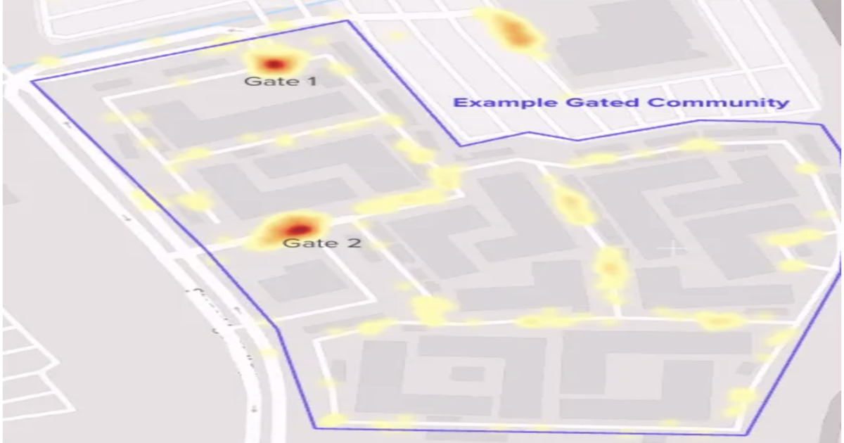
Lyft details a new pickup experience to improve reliability in gated communities, where 25–30% of rides face routing and access challenges. The system uses mapping signals, boundary detection, and routing improvements to reduce cancellations and coordination overhead between riders and drivers, highlighting how real-world constraints drive evolution in geospatial systems.
By Leela KumiliRead on the original site
Open the publisher's page for the full experience